Mumbai Orange Alert: Heavy Rainfall Sparks Flood Fears on Sep 29
 Sep, 29 2025
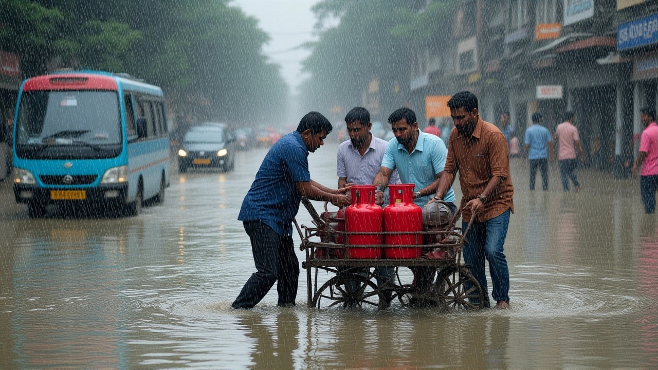
When India Meteorological Department (IMD) issued an orange alert for Mumbai on Monday, September 29, 2025, the city braced for a night of relentless downpours. The alert, formally titled Mumbai Orange Alert, followed a red alert that had already drenched the metropolis on September 28. Here’s the thing: the rain isn’t just water—it’s a catalyst for traffic snarls, power strain, and flood‑prone neighborhoods battling high tide.
Background: Mumbai’s Monsoon Legacy
Mumbai’s monsoon season usually peaks between June and September, with average monthly rainfall hovering around 380 mm. This year, the city has already logged a staggering 445 mm by the 29th—well above the norm. Historically, an orange alert signals "very heavy" rain and possible flooding, while a red alert warns of "extremely heavy" conditions. The twist is that the city’s topography—low‑lying coastal plains edged by the Arabian Sea—amplifies any excess water, especially when tides rise.
Current Weather Alert Details
IMD’s latest bulletin paints a picture of “generally cloudy skies with heavy to very heavy rainfall across the city and its suburbs.” The agency warned of isolated showers that could pour at rates exceeding 100 mm per hour. The Colaba station logged 54 mm in the last 24 hours, while the Santacruz observatory recorded a modest 12 mm—numbers that, combined, tell a story of uneven but intense precipitation.
High‑tide forecasts are equally worrisome. A tide of 3.01 metres is slated for 3:27 pm on September 29, followed by a 3.22‑metre surge at 4:56 am on September 30. Low tide sits at 1.58 metres later that evening, offering a narrow window for the city to drain. The timing of these tides means water‑logged streets could turn into shallow rivers if the rain doesn’t ease.
Impact on Transportation and Daily Life
Local trains—Mumbai’s lifeline—have already felt the strain. Central Railway and Western Railway reported delays up to 45 minutes as tracks became slick and signaling equipment struggled with visibility. Some stations saw water levels rise to waist‑high, forcing staff to halt services temporarily.
Bus operations, managed by Brihanmumbai Electric Supply and Transport (BEST), have been more resilient, running without major diversions. Still, commuters are advised to avoid low‑lying routes near the Mithi River and to keep an eye on real‑time updates via the BEST app.
Beyond transport, the city’s water supply remains functional thanks to the Bhatsa, Veera, and Tulsi systems feeding the Panjarpur Water Treatment Plant. Yet officials cautioned that water‑logged roads could damage underground cables, potentially leading to localized outages.
Official Responses and Safety Advisories
A senior civic officer, speaking at a press briefing on Sunday morning, echoed the IMD forecast: “Expect cloudy skies with heavy to very heavy rain, thunderstorms, and gusty winds reaching 40‑50 km/h. Isolated pockets may see extreme downpours.” The same officer urged residents to stay clear of trees during lightning, avoid crossing flood‑marked bridges, and refrain from spreading unverified rumours on social media.
Police and municipal bodies have deployed over 150 rapid‑response teams to patrol flood‑prone zones in Thane, Raigad, and Palghar. These districts share the same coastal vulnerability and have been placed under the red alert that will stay active until Monday morning.
Public health experts warned that standing water can become a breeding ground for water‑borne diseases, especially dengue and leptospirosis. Hospitals across the city have stocked extra IV fluids and antivenom, ready for any surge in cases.
Looking Ahead: Forecast and Potential Risks
IMD predicts the western‑moving depression, currently centred over Vidarbha, will continue to dump heavy rain across Maharashtra until September 30. The system’s forward speed is about 43 km/h, moving westwards through Marathwada and adjoining Madhya Maharashtra. That means the next 24‑hour window could see another 70‑90 mm of rainfall in Mumbai’s western suburbs.
Given the confluence of heavy rain, high tide, and already saturated soils, the risk of flash floods and water‑logging remains high. Residents of low‑lying colonies such as Dharavi, Mankhurd, and Chembur should keep evacuation routes ready and consider moving valuables to higher ground.
In short, while the city’s infrastructure has shown resilience, the coming days will test Mumbai’s emergency preparedness. The combination of meteorological forces and urban density makes every drop count.
Key Takeaways
- IMD issued an orange alert for Mumbai on Sep 29, 2025, after a red alert the day before.
- Rainfall measurements hit 99.44 mm in the western suburbs within 24 hours.
- High tides of 3.01 m (Sep 29) and 3.22 m (Sep 30) raise flood concerns.
- Local trains delayed; BEST buses running; water supply stable.
- Authorities advise staying clear of flood zones, avoiding trees during storms, and checking official updates.
Frequently Asked Questions
How will the high tide affect flood risk in Mumbai?
The 3.01‑metre tide at 3:27 pm on Sep 29 coincides with the peak of the heavy rain, meaning drainage systems may be overwhelmed. Low‑lying neighborhoods can expect water to linger longer, increasing the chance of street-level flooding.
What transportation options remain reliable during the alert?
BEST buses are operating without major diversions, making them the most dependable option. Train services are running but with delays; commuters should check live updates on the Western and Central Railway portals.
Which districts besides Mumbai are under a red alert?
The red alert extends to Thane, Raigad and Palghar. Residents there should follow the same safety guidelines as Mumbai.
What health precautions should residents take?
Avoid standing water whenever possible, keep all food covered, and use mosquito repellents to reduce dengue risk. If you experience fever or abdominal pain, seek medical attention promptly.
When is the next forecast update expected?
IMD releases updates every six hours. The next bulletin is slated for 2:00 pm on Sep 30, providing fresh data on rain intensity and tide projections.